
Sorry, we couldn't find anything that matches your search.
Destination
Famous Places to Explore in Hyderabad
A vibrant city with the imposing...
Raipur Tourist Places | Best Place to Visit
The stronghold of several erstwhile...
Ahmedabad
Declared as India's first UNESCO World...
#
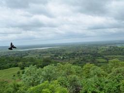
Swathed by cedar, rhododendron, fir and Himalayan oak trees, the state capital of Himachal Pradesh is one of the most popular hill stations of India. As the former 'summer capital' of British India, Shimla has a rare range of built heritage and is surrounded by thick forests of pine, Himalayan oak, flowering rhododendron and tall cedars. This magnificent setting and picture of an idyllic retreat in the mid ranges of the Himalaya mountains is framed by high peaks that trace a snowclad line across the north. Today's Shimla retains a substantial measure of a distinct lifestyle that has grace, leisure and elegance as its hallmarks.
-
 Start : Shimla
-
 End : Chitkul
-
 Time : Four Days

,,,,/content/incredible-india-v2/en/destinations/mysore/the-mysore-palace--amba-vilas-.html,
Day 1 Stop 1 - Kufri-Fagu

Kufri is about 16 km from Shimla and has long been famous for its ski slopes and fine views. The Himalayan Nature Park is also at Kufri and the area has a fair amount of options for family entertainment. Further, 6 km from Kufri is a tiny village, Fagu, which rests astride a mountain saddle along the Hindustan Tibet Road. In the open patches, the valleys hold hamlets, orchards and neatly terraced fields. Himachal Tourism's hotel 'Apple Blossom' is available at Fagu.
,,,,/content/incredible-india-v2/en/destinations/mysore/the-mysore-palace--amba-vilas-.html,
Day 1 Stop 2 - Narkanda
Narkanda lies 64 km from Shimla and has a choice of ski runs, thick woods and superb views. The peak of Hatu rises over this small town and is covered with thick woods. The views from the top are quite amazing. Near Narkanda lies Himachal's apple growing heartland and the settlement of Thanedhar and Kotgarh. It was in this belt that Samuel Evans Stokes introduced the American varieties of apple that went on to transform the economy of the area and today, make this a delightful area to visit. Baghi and Khadrala lie along a section of the old Hindustan Tibet Road, near Narkanda, and are set in thick woods interspersed with apple orchards. Himachal Tourism’s hotel 'The Hatu' is available at Narkanda.
,,,,/content/incredible-india-v2/en/destinations/mysore/the-mysore-palace--amba-vilas-.html,
Day 1 Stop 3 - Hatu Peak
Towering over Sutlej valley, Hatu Peak at 3400 meters altitude is one of the highest peaks in the hills near Shimla. From Narkanda, one needs to take a taxi or do a 8 km trek through forest country to the mountain top destination. Though a motorable road has been constructed, an uphill walk through the woods from Narkanda is a better experience of the hills. Atop the mountain a temple dedicated to demon slaying goddess Kali exhibits the local architecture and wood craftsmanship skills. The 360 degree views from the mountain top are deep and expansive making the trek a worthy one. A level walk through a dense oak forest opens onto Jaw Bagh, an alpine meadow, which only adds to the scenic value of the getaway. After visiting Hatu Peak, come back to Narkanda and visit the Skiing ground (Dhomori ground). Then visit the local market and night stay at the hotel ' The Hatu'. Private hotels are also available in the area for stay.
,,,,/content/incredible-india-v2/en/destinations/mysore/the-mysore-palace--amba-vilas-.html,
Day 2 Stop 1 - Tanni Jubbar Lake
This is a small and secluded water body, located near Thanedar in the hills of Narkand area. It is a rain water fed lake amidst scenic environs of verdant apple orchards and lofty pine trees. A shrine dedicated to Nag Devta (the God of snakes) is also located near the lake.
,,,,/content/incredible-india-v2/en/destinations/mysore/the-mysore-palace--amba-vilas-.html,
Day 2 Stop 2 - Rampur
After visiting Tani Jubbar lake, come back and proceed to Rampur. The town of Rampur (about 130 km from Shimla) is situated on the banks of the river Sutlej and was the seat of the former princely state of Bushair. It was a major entry point along the old trade routes. Rampur benefitted from a wide range of economic and cultural exchanges. Today, Rampur is a bustling town that retains a substantial measure of its past and is still a melting pot of the cultures of the region and has its historical palaces and temples. Rampur Bushehar is the gateway to Kinnaur and Spiti. Himachal Tourism’s hotel Bushehar Regency is available at Rampur.
Held after the year's harvest, Lavi is a historic trade fair held every year from 11 November to 14 November with much fanfare at Rampur Bushair. Stalls are set up at open places in the town and traders from near and far do brisk business in selling local produce, handicrafts, handloom products and other manufactured goods during the fair. Kinnauri woolens, garments, wool, pashmina, shawls, handwoven tweeds, metalware, pottery, jewellery, crunchy apples, Kinnauri horses, dry fruits like chilgoza, walnuts, almonds and dried apricots are high demand products at Lavi. The evenings are given to cultural performances where the crowds are entertained with lively music with a popular star usually putting on a show. Himachal Tourism's Hotel 'The Bushehar Regency' is available at Rampur.
,,,,/content/incredible-india-v2/en/destinations/mysore/the-mysore-palace--amba-vilas-.html,
Day 2 Stop 3 - Sarahan
About 175 km from state capital Shimla, Sarahan is steeped in legend, hill architecture and remarkable natural beauty. Far below in the valley tumbles River Sutlej. Across lie the snow-covered Shrikhand peaks and a host of other mountains that divide the Sutlej and Beas valleys. This is an area closely connected with the epic Mahabharata and the exile of the Pandavas. Sarahan itself is surrounded by fields and orchards, and small villages with remarkable examples of local architecture. Sarahan is revered as one of the fifty-one Shakti Peethas and the temple of Bhimakali is a resplendent example of indigenous building skills. For several centuries this was also the capital of the former princely state of Bushair. Near the temple complex is a pheasant breeding centre, which is of great attraction. Himachal Tourism’s hotel 'The Srikhand' & cottage is available at Sarahan for night stay.
,,,,/content/incredible-india-v2/en/destinations/mysore/the-mysore-palace--amba-vilas-.html,
Day 3 Stop 1 - Reckong Peo-Kalpa
From the Hindustan Tibet Road, the turn off for Reckong Peo is at Powari (1990m) and 7 km at the end of a climbing side-road, this is the district headquarters of Kinnaur. It faces the majesty of Jorkanden (6473 m) and the Kinner Kailash Mountain (6050 m). The latter is regarded as one of the mythical homes of Lord Shiva and by its side is a 79 foot high rock formation that resembles a ‘Shivalinga’ that changes colour as the day passes and is visible to the bare eye on a clear day. The ‘Parikrama’, circumambulation around the base of the mountain is a seven to eight day trek. Also visible on the stretch is the peak of Raldang (5,499 m).
Just half an hour’s drive from Reckong Peo, takes you to Kalpa, which was once known as Chini. This still has a traditional ambience and much of the old architecture. The Narayan-Nagini temple is an example of local craftsmanship. There are a couple of Buddhist monasteries at Kalpa, including the Hu-Bu-Lan-Kar gompa, said to have been founded by Rinchensang-po (950-1055 A.D.). Himachal Tourism’s hotel ‘The Kinner Kailash’ is available at Kalpa for night stay.
,,,,/content/incredible-india-v2/en/destinations/mysore/the-mysore-palace--amba-vilas-.html,
Day 4 Stop 1 - Sangla
Of all the side valleys of the river Satluj, the Sangla valley is perhaps the most beautiful. Unlike most other major streams of the area that flow north to south, the river Baspa rises in the mountains of adjoining Uttarakhand and flows north-west to meet the churning torrents of the river Satluj at Karcham. To get to Sangla, the valley carved out by river Baspa, one has to leave the Rampur - Reckong Peo highway at Karcham and drive uphill on the left bank road with hairpin bends. Having become popular with tourists, Sangla has some good eating and staying options.
During the journey to the Sangla Valley, every turn and angle reveals a valley that is strikingly beautiful. Like the rest of Kinnaur district, there is no urban center in the valley and like most other parts of the district, the people of the valley practice an unusual mix of Trans-Himalayan (Vajrayana) Buddhism and Hinduism. The village Sangla has the main market of the valley where essentials are available. Some hotels and rest houses are based here.
,,,,/content/incredible-india-v2/en/destinations/mysore/the-mysore-palace--amba-vilas-.html,
Day 4 Stop 2 - Kamru
A kilometer above Sangla village stands the tower-like fort of Kamru. This wood and stone structure was the original seat of the rulers of Bushair. Kamru is a dense cluster of houses and is surrounded by fields and orchards and incidentally, some of the finest apples of Himachal come from here. The main gate of Kamru has an image of the Buddha whose blessings are sought before entering the confines of the village. A series of low gates through the hamlet lead to the tower that rises five stories high. It serves as an excellent example of an architectural style that is unique to this part of the world. The stronghold has an image of the Hindu deity, Kamakhya Devi (Kamakshi) installed in the upper storey. This image is said to have been brought here several centuries ago from Assam. The village also has a fifteenth century temple of Badrinath.
,,,,/content/incredible-india-v2/en/destinations/mysore/the-mysore-palace--amba-vilas-.html,
Day 4 Stop 3 - Batseri
Set on the left bank of the Baspa, the village is approached on foot for about a kilometer. The village has some interesting architecture, cobbled paths and the superbly crafted temple of Badri Narayan. There is also a temple dedicated to the Buddha. An interesting little piece of sacred architecture is the large prayer wheel housed in a shelter high up the village that is turned by a stream’s waters.
,,,,/content/incredible-india-v2/en/destinations/mysore/the-mysore-palace--amba-vilas-.html,
Day 4 Stop 4 - Chitkul
After exploring Sangla and surroundings, proceed to Chitkul, the last inhabited village on the Indo-Tibet border. Chitkul, in Baspa valley, is 25 km from Sangla. The motorable road ends at this village and any further journey has to be done on foot. In the rarefied air with some slopes of the highlands around the village sliced into terraced fields, a crystal clear River Baspa flowing through bestows immense beauty on this habitation. Camping by the river can evoke spirituality. The village has a small temple dedicated to goddess Mathi, a local deity sitting in its centre. Any visit to Kinnaur is incomplete without a visit to Chitkul.
The months of April to October are a good time to visit the destinations in Kinnaur. In winters, starting from November, the temperatures start to fall and they do drop well below the freezing point in December and January. The nearest airport for Kinnaur is at Jubbarhatti (Shimla). Reckong Peo, the district headquarter, is 253 km from the airport. The closest train station for Kinnaur is Shimla. From the train station, Reckong Peo is 232 km. However, Kinnaur is well connected by the highway that runs from Chandigarh, Shimla and goes past Rampur to get to Reckong Peo, from where it reaches Kaza in Spiti valley after passing through Pooh, Nako and Chango. An alternate route to Kinnaur starts from Manali and goes over Rohtang and Kunzum Pass to reach Kaza, before descending through Spiti and Sutlej river valleys to get to Kinnaur. Public state transport operates regular bus services to most destinations in Kinnaur. Taxis can be availed from Delhi, Chandigarh or Shimla for a customized tour of Kinnaur.